Intuitive. Innovative. Efficient.
Our Web Client for the widely distributed infra3D services. Web-Client requires a recent browser version
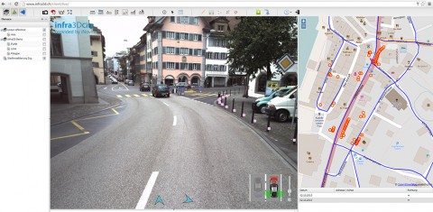
infra3D Web Client is very intuitive for anyone to use and the image data can easily be used, password protected, on the internet. The available functions facilitate the simple procurement of information or mapping of objects.
Potential applications
- Conducting virtual field surveys
- Reconnaissance
- GIS inventory
- Geodata collection and mapping work
- Quality control of existing digital images

Benefits
- Simple navigation in infra3D image data service
- Exact measurement of points, distances or surfaces
- Precise mapping of geo-object
- Correctly positioned superimposition of geodata onto image data
- Import and export of geodata via the interfaces DXF, ESRI Shape File, GML or KML
- Support of linear coordinate systems
Simple and flexible use – on your computer and mobile
infra3D Web Client runs in every recent web browser: Google Chrome, Mozilla Firefox, Safari and Internet Explorer.
Thanks to touch screen optimised Client, infra3D service can be used on your mobile.
Configurability enables maximum individualisation.
The functionalities provided in Web Client for users, retrievable image data and visible or editable geodata layers can be configured simply and according to your needs.
Range of functions
- Navigation: Facilitates image sequence playback, the intuitive selection of desired camera views, access to the image data timings available in infra3D service or the intuitive choice of direction at crossings.
- Map interface: the map interface enables the network to be depicted and navigated in the image service. The map service can be defined to the customer’s specifications.
- Basic functions: allows the manual adjustment of image brightness, visualisation of 3D-geometry quality or the simple extraction of the snapshot view.
- Measuring functions: support users when extracting various dimensions in the image data with the one-click procedure. You can designate distances, areas, perpendicular distances, or high resolution cross-sections.
- Layer: Existing geodata such as utility lines can be placed correctly and transferred to the image data. Feature data can be easily retrieved and displayed.
- Feature Editing: geodata collection and tracking directly with infra3D service. Feature classes can be defined for specific users or existing data sources can be integrated. The geodata collected or tracked can be exchanged via interfaces such as GML, DXF, KML, GeoJSON or ESRI Shape Files.
- Linear referencing: depositing an additional linear reference system based on existing axis data. Geoobjects can be mapped in this system or located objects can be correctly cross-faded.
infra3D New Release 3.15 Features
For more videos please click here


